
Guide to the Geology of the Loop Head Peninsula
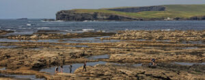
The Loop Head Peninsula in southwest County Clare is where the River Shannon flows into the Atlantic Ocean. Dramatic cliff-scapes, stony coves, sand beaches and estuarine mudflats, provide an irresistible invitation to the independent traveller who is keen to enjoy naturally formed architecture, oceanic skies and places less travelled.
The cliff face exposures of the southwest and north sides of the peninsula are quite accessible and have been the subject of intense study by geologists since the late 1950s, as they illustrate the development of a large scale submarine fan delta that evolved over 7 or 8 million years, during the Upper Carboniferous Period, 320 million years ago.
In sharp contrast to the dramatic cliffs of the west and north, the southeastern shoreline on the Lower Shannon Estuary presents a different picture of gently sloping shores where the river and tidal processes have formed sand beaches and mudflats.
Advisory: Use common sense and caution particularly when close to cliffs. Rocks are very slippery in wet conditions.
An Ordnance Survey Map (no. 63), is strongly recommended as road signs are sometimes ambiguous or non-existent. Maps are available at the Irish House Newsagents in Kilkee and in the Dolphinwatch Information and Booking Centre in Carrigaholt Village.
Tide tables can be of great use and can be downloaded free at www.sfpc.ie/ marineoperations/tides or contact Dolphinwatch 065 905 8156.
The Geological Context
The layout of the earthʼs continents around 320 million years ago was very different than today. This part of the earthʼs crust was positioned close to the equator off the southern coastline of an ancient continent and was one of a number of interconnected marine basins stretching from what is now Russia through Western Europe, Britain, Ireland and into the Eastern USA.
Lowering Sea Level
Tectonic movements in the Earthʼs crust had caused an uplift of the land and consequently a drop in relative sea level resulting in the emergence of large areas of previously submerged coastline. Great rivers transported eroded sand and clay from the continent to the shoreline forming extensive deltas.
Carboniferous Jungles
The climate was hot and humid. Deltaic forest swamps covered large areas of coastline. The vegetation was dominated by dense and very lush forests of giant tree ferns and other early tree-like plants. As this vegetation died and became buried in the swamp, turning into peat and later coal, a large amount of carbon was removed from the atmosphere increasing the amount of oxygen to almost double what it is today. Flying insects and cockroaches whose size is limited by their respiratory systems were thus able to grow to gigantic proportions. Poisonous centipedes grew over 2 meters long and reptiles up to 6 meters.
The vast, economically important coalfields of North America and Europe were formed in these coastal deltaic swamps. This period of the Earthʼs history is known as the Carboniferous from the Latin meaning coal-bearing.
Index Fossils
Out in the sea there was abundant marine life such as corals, bivalves, molluscs, fish and early sharks. Most importantly for geologists were the free swimming ammonoids called goniatites, spiral shelled relatives of the squid and octopus which looked similar to the modern day nautilus but a lot smaller, approximately 10 – 20 mm across. The numerous evolutionary stages of this extinct animal have been meticulously documented allowing geologists to accurately date and correlate the rock strata where these “index fossils” occur.
Effects of Glaciation on Sea Level
Despite the hot humid conditions at the equator, two very large ice sheets advanced and retreated periodically between the south pole and up to 30 degrees south of the equator. Water stored in the ice and then released when the ice melted caused major fluctuations in global sea levels.
Development of the Submarine Fan Delta
Over a period of 7.5 million years (318.5 – 311 million years ago) a huge river system carried sand and clay out to sea where it was deposited in a succession of vast sheets to form a large submarine fan delta just off the coast of the continent. Due to pressure and heat caused by subsequent layers of sand and mud, the sediments turned into hard rock which was later pushed up above present day sea level by many movements of the earthʼs plates.
For most of the following 300 million years, Ireland was above sea level and subjected to weathering which stripped away a lot of its rock mantle, including most of the coal deposits formed in the Carboniferous period.
Geological Trail through Time and Delta
As you make your way around the coastline you will see different patterns occurring in the cliffs, reflecting the varying geological forces at work at the different locations on the ancient river delta and outer submarine fan.
To present a logical order and best explain the geological processes at work, this guide starts at the oldest of the rock formations and works up through time.
The Ross Sandstone Formation – Sheetlike Turbidites
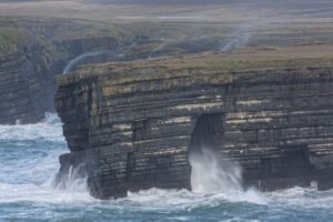
Along the south side of the peninsula from Carrigaholt to Loop Head and then around to Ross on the north side of the peninsula, we are looking at what was the outer fan delta formed in water about 1 kilometre deep. Sand and mud were carried downslope from the river mouth by high-speed underwater avalanches or turbidity flows which settled out to form vast sheets of sediment known as turbidites.
At Kilbaha Bay, along the coast road between Kilclogher and Kilbaha, the layering of these long continuous turbidite sheets can be clearly seen. Looking closer at the top surfaces of these beds, observe the ripples and grooves formed by the action of sea currents on the ancient seafloor especially when the sun reflects on the wave lapped ledges. Geologists use these ripple marks to indicate the direction and strength of the currents which brought the sediments into the basin.
Loop Head – the Folds
Moving on to Loop Head itself and beyond the Light House to the sea stack, known as Diarmuid & Grainneʼs Rock, where the successive layers of sand rich turbidites are actually the top part of a giant “box fold”. Look out to sea, then turn right (east) and see the northern side or “limb” of this fold, seen as a very smooth and vertical layering of rock from sea level to cliff top. The southern limb of this fold is on the south side of Loop Head. This folding and tilting is visible throughout the peninsula and was caused by the pressures of converging continental plates. The folds are aligned in an east west direction reflecting the source of pressure which came from the south as the African continental plate pushed northward about 300 million year ago, long after the sediments had turned into hard rock. This particular fold has allowed Loop Head to resist the battering of coastal erosion.
Referring to these folds, Mary John Knott in her delightful book Two Months in Kilkee, published in 1836, wrote that the “fanciful curved strata present extraordinary appearances.”
The converging continental plates which lead to the folding process produced enormous heat and pressure, transforming silica in the sand rich water into veins of quartz crystal which formed along the edges of the fissures or cracks in the rock. So look out for the odd glint of quartz.
Ross Point – The Bridge and the Mudslide
At Ross Bay and Ross Pt. a good place to stop is the car park (signposted Bridges of Ross) and follow the trodden path to the last surviving bridge or natural arch formed by coastal erosion.
Looking below the car park into the cove, there are more ancient ripples as well as larger “scours” or scoop-shaped depressions excavated from the beds of sediment by fast-flowing currents.
At Ross, we are moving a little further away from the deep water basin towards the ancient river mouth and delta proper. The Ross “Mudslide” can be clearly seen at the far side of the cove where the muddy sediment became unstable and collapsed or slumped. On top of this slump are some “sand volcanos”, a few feet across, formed as the water bubbled up out of the slump as it settled.
The Gull Island Formation – Muddy Chaos
This section is probably for the more able-bodied and adventurous, requiring walking and good orientation, and where an ordnance survey map would prove itʼs worth.
Here on the south side of Tullig Pt., near the village of Cross, we have moved up slope away from what was the ancient deep water outer fan and have arrived at the steeper and shallower delta front slope below the delta “shelf”.
Here, at the foot of the delta plane or shelf, layers of sand, mud and silt were being deposited extremely quickly causing the deposits to become gravitationally unstable and to slide and slump down slope giving a mainly chaotic appearance, very different to the clearly defined and regular, stacked bedding of the Ross Sandstones of the submarine fan.
This formation of relatively soft mud and siltstone runs right through to the south side of the peninsula and is exposed in the low bluff shorelines between Carrigaholt Castle and Doonaha.
The Coast Road to Kilkee – the Deltas
Most of this section of the ancient delta is easily observed on the coast road from Moveen and Kilkee. Not well signposted, this road can be found by turning left, towards Kilkee at the Kerry Co-op Agri Store and fuel pumps at Bella and after about 1 km, turn left at the fingerboard signpost for Castle Pt. (fishing). This road allows for spectacular and often 3- dimensional views of the cliffs and is an essential part of the full Loop Head experience.
After about 1/2 a mile the road reaches the coast at a cove known as the Moveen Goleen where the sharp-eyed and intrepid observer may find the fossilised remains of an ancient tree-like giant ferns or lepidendrons in the cliff face. Growing up to 40 metres tall in very dense forests, they were one of the most important plants in the formation of carboniferous coal deposits. These were probably washed out off the land by a major event, such as a deluge or even a tsunami.
From here, bear left to stay on the coast road.
The cliff face exposures from here to Kilkee are known as the Tullig, Dunlickey and Kilkee cyclothems, so called as they are repeated cycles of sedimentation brought about by the regular (c. every 65, 000 years) and substantial (approximately 45-75 metres! ) changes in sea level caused by the advance and retreat of the southern hemisphere ice sheets, which exposed and submerged the delta front in a periodic rhythm.
The typical sequence in the cliff face is lighter coloured sandstones at the top where the sandy shallow water delta shelf extended out to the basin over the earlier mud and silt deposits on the slope below the shelf. The layers of mud and silt in the lower cliff below the sandstone capping were formed at the shelf margin where the slope was steep and unstable and so were often slumped and deformed.
The picture is made more complex by recent studies showing that the distributary river channels at the delta front eroded and cut down deep valleys through earlier deposits during periods of falling sea levels. These incised river valleys were later infilled by sediments as sea levels rose once more.
Thin turbidite sheets seen earlier in the deepwater fan appear again to show a periodic return to deep water conditions further illustrating the major sea-level changes.
There is certainly a lot to take in – not least of which is the series of sea stacks along this section of coast, formerly part of the mainland and now separated by coastal erosion, as well as parts of the cliffs that are in the process of eroding into stacks.
All of these sea stacks are very important for ground-nesting seabirds – such as herring gulls and black-backed gulls which need the rodent-proof security of the offshore nest sites for the safety of their eggs and young.
One such stack with some ruins of small cabins on the top is called Bishopʼs Island where it is said that the Bishop of Killaloe went to escape the plague. This is close to St. Caoidhʼs Well (pronounced “kee”) a small white structure in a field to the south side of the road. Cill Caoidh or Kilkee means the church of Caoidh.
The Pollock Holes
The coast road will bring you right down to the magnificent horseshoe bay of Kilkee, also known as Moore Bay.
Turn left here and follow the road to the car park just before the Pollock Holes, a series of rock pools teeming with oceanic life in the dramatic setting at the mouth of Moore Bay. As the tide goes out, these pools become accessible for swimming and snorkelling and are truly one of the gems of Kilkee.
Further north from Kilkee the cyclothem exposures in the cliffs and coves are equally spectacular.
To the Shelter of the Shannon
After the drama of the ocean cliffs you may enjoy something more tranquil.
Head out along the Kilrush Road for about 2 km and turn right at Keaneʼs Oyster Bar and Lisdeen Church. This road will take you across the Black Weir Bridge at the head of Poulnasherry Bay, a vast expanse of tidal mudflats and an internationally important habitat for wading birds.
Look left from the bridge to see the frames of an old turf barge sticking up from the mud at low tide, a remnant of the Shannon turf trade, which was a very important part of the commercial life of the peninsula.
About 400 metres past the bridge, the main road turns to the right. If you take the side road to the left, this will take you along the eastern side of Poulnasherry Bay to its narrow entrance at Cammogue Point and the lower estuary of the River Shannon – Irelandʼs longest river.
Look across to Scattery Island with its Viking period round tower, built by the monks in a vane attempt to resist the ravages of the raiders. The island was formed by a deposit of boulders and clay left behind when the last ice sheets began to retreat about 18,000 years ago.
Follow the road westward to the cross roads with Querrin National School on your right. At this point, turn left and go downhill for the sheltered shores at Querrin Pier.
You may want to walk out at low water to Querrin Island, a long glorious sand spit used to graze horses which extends eastward onto tidal flats, another important refuge and foraging area for ducks, geese and wading birds.
The road west along the tidal creek at Querrin Shore brings you to the old graveyard and a T junction. Turn right here and head up to the main road between Querrin and Carrigaholt where you should turn left to continue along the shore of the lower Shannon Estuary. There are left turns along this road which will bring you to quiet sand and shingle beaches.
The bridge over the Moyarta River brings you into Carrigaholt with its 15th century castle, where you can look south to the Mouth of the Shannon and the Napoleonic Gun Battery on the headland of Kilcredaun where the Ross Sandstone Formation appears once again.
Special thanks go to the many geologists whose work on this peninsula has helped us to understand how this beautiful part of Ireland came about. I would particularly like to thank Andy Pulham and remember also the dedicated work and friendship of the late Trevor Elliott.
Geoff Magee Dolphinwatch Carrigaholt
Wild Water, Loop Head, County Clare, Ireland